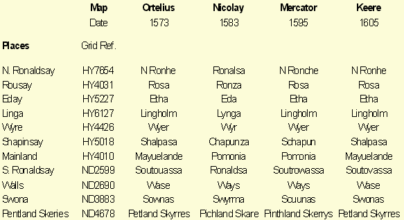


Though published at the beginning of the seventeenth century, the map by Keere (1605) belongs in the same category as those by Nicolay, Ortelius and Mercator. Table 2 shows a comparison of the spellings used to identify a number of locations common to all four maps. As described in the Methods section, the locations illustrated were selected from the full list of those named on the maps because they were widely represented on each of the maps. They were also selected as showing variations in their spelling between the maps which produced patterns characteristic of the individual maps.
From the table, it is clear that the map by Keere was more closely influenced by the 1573 map by Ortelius than by the later maps by Nicolay and Mercator which agrees with the link between the Ortelius and Keere maps mentioned by Moir (1973; p. 34, 1).
This relationship also illustrates a recurring theme in the history of Orkney maps that many maps were published based on others which had long been superceded by newer more accurate versions.
Table 2. Place names on pre-1620 maps
Early Maps (2)