


Origins of the 1550-1620 Maps
Moir (1973; 1) presents historical evidence regarding the origins of the Mercator/Ortelius maps which suggests that the map by Ortelius (1573) was based on an earlier map engraved by Mercator from an manuscript of unclear provenance. Moir comments that the Mercator map of Scotland published in 1595 was a marked improvement on his earlier map used by Ortelius. This observation is supported by the current estimates of the error in their outlines of Orkney which were approximately 7100 for the Oretlius map and 2300 for the Mercator map of 1595.
The map by Nicolay published between the above two dates appears to have had a separate lineage possibly being derived from a manuscript map prepared by Alexander Lyndsay (Moir, 1973). Much of the error found with each of these maps was associated with use of inappropriate scaling in one or both directions (Table 1).
1. Moir (1973), The Early Maps of Scotland. Volume 1. p. 14 The Royal Scottish Geographical Society , Edinburgh
Early Maps
The first recognizable representations of Orkney were on maps by Ortelius (1573), Nicolay (1583) and Mercator (1595) but these were on maps covering the whole or a large part of Scotland.
They named most of the major islands within the Orkney group but their shapes and their locations relative to each other were wildly inaccurate. There were relatively few other features named the vast majority being sites with religious dedications.
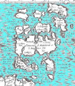
Portion of G. Mercator - 1595
“Scotia Regnum”