

Orkney 1750-1890
In 1791 von Reilly published a map which, as detailed above, is almost a direct copy of the Orkney portion of Blaeu’s map of Orkney and Shetland published in 1654. It is therefore a most striking example of how maps continued to be published long after much improved versions were available. However, most of the maps published from 1760 until 1850 were based on Mackenzie’s map of 1750.
The present investigations have suggested that maps based on Mackenie’s survey can be recognized by a simple determination of the position of Copinsay relative to the Mainland of Orkney. Thus, the maps by Aberdeen, Huddart, the French Ministrie de la Marine, Arrowsmith, Brown, Scott, Thomson, Walker, Lothian and Black all show the characteristic displacement of Copinsay towards the NNE.
The map by Aberdeen (1769) is particularly interesting as it charted the lands of the Earldom of Orkney and was on a much larger scale than Mackenzie’s map. It gives details of individual land holdings throughout the County and contains a wide selection of place names. The detailed information incorporated on the map strongly suggests first hand knowledge and its place name spellings are probably those obtained directly by Aberdeen or his immediate associates. Despite this, the map outline shows many of the errors characteristic of maps derived from Mackenzie’s survey. This is perhaps unsurprising since Aberdeen was surveying the Earldom estate for Sir Laurence Dundass and Dundass had recently purchased it from the Earl of Morton, a subscriber to 30 copies of Mackenzie’s charts!
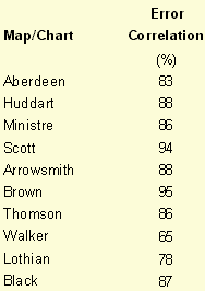
Table 7. Correlation of maps with Mackenzie’s chart of 1750
Detailed analysis of the errors in these maps resulted in the correlations with those of Mackenzie’s map listed in Table 7 and Table 8. With correlations as high as these, it becomes difficult to assess relationships within the group on this basis alone and information from differences in the spelling of place names was more useful.
Locations were selected which had names whose spelling was found to differ characteristically within the maps of this period. The differences in place names were then compared across maps and the results are presented in Table 9.