


Murdoch Mackenzie Survey
Shortly after the publication of Moll’s map, probably between 1745 and 1749, a survey of Orkney began which was to dominate Orkney maps for a century. This was the work of Murdoch Mackenzie. He was the first in Orkney to utilize a system of interlocking triangles to determine the location of prominent physical features and he provided an interesting exposition of his methods in the preface to his publication of the charts in a volume entitled “Orcades”.
Much has been written about Mackenzie’s techniques both by his contemporaries and in subsequent academic studies but all agree that his survey of Orkney resulted in a dramatic improvement in the representation of the county. In this he was aided by both his own insight and the vagaries of nature. Thus he realized that he could utilize the freezing over of the “Loch of Stenhouse” (Harray Loch) to lay down his crucial initial baseline along the flat and unrestricted surface of the frozen loch. From this he was able to begin measuring a series of triangles starting with determining the angles to beacons built on top the surrounding hills. Thereafter, he developed a series of primary and secondary triangles covering the whole of Orkney. Finally he checked the accuracy of his survey by comparing measured latitudes and longitudes of Kirkwall and Brides Ness in North Ronaldsay with those computed by survey.
The improvement in the outline which he thus achieved is readily apparent from the error figures shown in Table 1. Fig 4 gives an indication of where residual errors remained. Notable among these is a marked displacement of Copinsay towards the NNE of its true position. This is reflected in many maps published from1750 until the appearance of an accurate Admiralty chart of Orkney a century later and is indicative of maps based on Mackenzie’s survey.
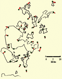
Fig. 4 Map by Mackenzie 1750.
The red lines join the true location of each point
to a square at its location on the antique map.
Copinsay