

Orkney 1680 – 1790
Maps based on Pont’s sixteenth century survey dominated Orkney cartography for most of the seventeenth century. However, towards the end of that period there appear to have been at least three new surveys of Orkney. John Adair persuaded the Scottish Privy Council to support his scheme to survey the counties of Scotland. Although various impediments frustrated full implementation of his plans, he produced a chart of Orkney in 1682 the origins of which are obscure (Moir,1973 p. 65, 1). Although the present assessment of its outline suggests that it was considerably more accurate than the contemporary chart by Collins (overall error 269 versus 1141), it appears never to have been published and exists only in manuscript form (Moir, 1983 p. 9, 3)
Captain Greenvile Collins surveyed the “Sea Coasts of England and Scotland” as “Hydrographer to the King” and published his surveys in “Great Britain’s Coasting Pilot” in 1693. This included two charts of Orkney, one covering the whole of the islands and the other “The cheife harbours “. Thirdly, Johannes van Keulen published a chart of Orkney in 1695 which appears to have been drawn from data provided by C.J. Vooght (4). Both the Collins and van Keulen charts gave a better representation of the outline of Orkney than maps derived from Pont’s survey. However, analysis of their errors showed no correlation between the Collins and van Keulen charts supporting the concept that they were based on separate surveys.
One strange feature of the Collins chart is the scale indicated on the map. This was shown as 4 “English” miles to the inch whereas the best scale to fit the map is approximately 3 miles to the inch. Fig. 3 a & b illustrate the errors associated with the chart if the original scale is used and after adjustment to the optimal scale for both latitude and longitude.
3. Moir, D.G. (1983) The Early Maps of Scotland. Volume 2. The Royal Scottish Geographical Society , Edinburgh
4. Tooley, R.V. (1979) Tooley’s Dictionary of Mapmakers, Map Collector Publications.
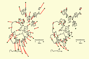
a
b
Fig. 3 Collins map of Orkney 1693.
(a) Original scale (4 miles / inch);
(b) rescaled to 3 miles / inch
The red lines join the true location of each point to a square at its location on the antique map.