

Some thirty years after Sanson, Morden published a map of Scotland with the characteristic Pont-derived outline of Orkney. Again the scale was small but Start Point and Eynhallow are identified while the only two places present from the list in Table 4 conform to the Blaeu pattern.
Finally, as late as 1791 von Reilly published a map of Orkney on a scale comparable to that of the Blaeu map and showing all the place name evidence listed in Tables 3 and 4 as characteristic of the Blaeu series. Thus the survey by Pont at the end of the sixteenth century dominated representations of Orkney through most of the seventeenth century and lingered on even into the late eighteenth,
Pont Maps (4)
The map of Orkney and Shetland published by Janssonius in 1646 is essentially identical with that of Hondius who was his brother-in-law. Although on a much smaller scale, the outline of Orkney in Sanson‘s map of 1665 is clearly derived from Pont’s survey. The use of a smaller scale inevitably resulted in fewer locations being named on the map and therefore the failure of Sanson to show the locations listed in Table 3 does not unambiguously identify the map as a derivative of the Hondius series. However, Table 4 lists differences in spellings of various place names between the two series of maps. Although only three of these locations are recorded on Sanson’s map, each agrees with the version of Hondius.
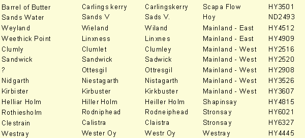
Table 4 Place name changes between maps derived from Hondius or Blaeu
Modern Name
Hondius /
Janssonius
Blaeu /
Von Reilly
Region
Grid Ref.