

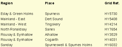
Table 3 Places shown on map by Blaeu but not on that by Hondius
Pont Maps (3)
At least two of the place names found on the Blaeu map but not on that by Hondius refer to such apparently minor features that they are unlikely to have been derived from anything other than Pont’s survey.
The precise origins of the maps by Hondius and Blaeu seem likely to remain unknown but they gave rise to two separate series of the Orkney and Shetland maps publication of which continued until as late as 1791.
Historical evidence suggests that engraved copies of the combined map were first produced by Willem Blaeu by 1628 when they were referred to in a letter from Blaeu to Sir John Scott. (Moir 1973 p.43, 1). However, this map did not appear in print until Johan Blaeu (his son) published his atlas of Scotland in 1654. Despite this, a version of the map at a slightly smaller scale was first published by Henricus Hondius in 1636. The very close similarity in the outline and place names on the two versions clearly indicates a common source. However, it is unclear whether Hondius’s map was based on a copy of his rival’s unpublished engraving of 1628 or derived directly from an earlier common source. Since his father, J. Hondius, had shortly before Pont’s death engraved a map of Lothian and Linlithgow based on a survey by Pont, direct communication between Pont and the Hondius family is a distinct possibility. On the other hand, there are seven place names on the Blaeu version of the Orkney and Shetland map which do not appear on that by Hondius (Table 3).