


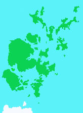
As shown above, Orkney consists of 70 or so islands of irregular size and shape. Historically, these presented map makers with a major challenge and early maps of Orkney are barely recognisable.
This site describes the development of maps and charts of Orkney from the mid 16th until the late 19th centuries. A brief survey of them clearly indicated that their development was not a smooth process. Instead, it involved a series of abrupt improvements in them. These were interspersed with the publication of inferior copies of each newly improved version and quite often, with further publication of maps based on even earlier maps.
If the historical evolution of the maps was to be understood, unbiased methods were required to assess the similarities and differences between the maps and thus determine their inter-relationships. The methods developed to assess these relationships and the conclusions drawn from them are described on the following pages.
GB

Orkney
The Mapping of Orkney